Timemap of distances in Spain by train
lainformacion.com
Graphic and research Chiqui Esteban
Published 2009 (updated with new prices and trains)
Software Flash, XML, Illustrator
Original article:
El mapa de las distancias temporales en tren en España
The information
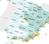
Spain has a very important network of trains, but with big differences between cities with AVE (High speed trains) and the rest, so the spanish map should be reshaped to show the real Spain depending on how long it takes you to arrive to your city by train (only direct trains).
The design
An initial animation shows how this reshaping happens. Some corners of the country are much further than other ones connected by AVE. You can alse draw a bubble map by prices, number of trains or a bar chart to compare when is better to go by car and when by train.


